


BayernInfo Maps
Description of BayernInfo Maps
BAYERNINFO MAPS is a navigation application that provides route planning for cars and travel information for public transport, including buses and trains. This app is available for the Android platform, allowing users to easily download BAYERNINFO MAPS to their devices. The app aims to facilitate travel across Bavaria by offering up-to-date information on traffic conditions, construction sites, and public transport schedules.
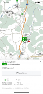
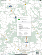
The app features precise GPS location services, enabling users to see their current position on the map and to plan routes from their location to their desired destination. This functionality is essential for efficient navigation and helps users make informed travel decisions. With full internet access, users can connect to server-side services that provide real-time map data and route searches.
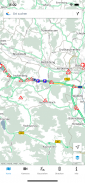
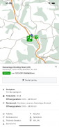
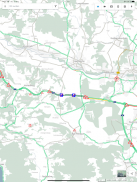
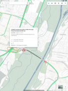
BAYERNINFO MAPS offers insights into the current traffic situation throughout Bavaria. Users can view detailed information on construction sites, road closures, and traffic reports, helping to minimize travel disruptions. The app also provides images from approximately 500 traffic cameras situated along major motorways and roads, giving users a visual representation of traffic conditions. However, it is important to note that access to these images may be limited due to recent developments in Europe.
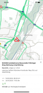
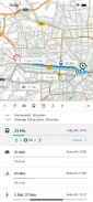
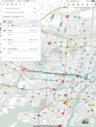
Intermodal route planning is another significant aspect of BAYERNINFO MAPS. This feature allows users to plan their journeys using various modes of transportation, including cars, buses, trains, Park & Ride facilities, bicycles, and pedestrian routes. This flexibility enables users to choose the most convenient and efficient mode of travel for their needs.
For those relying on public transport, the app provides real-time departure times and updates on delays, allowing users to stay informed about their travel plans. This information is critical for ensuring timely arrivals and minimizing waiting times at stations. The app also includes a construction site calendar, which is particularly useful for users who wish to plan their routes around ongoing roadwork.
BAYERNINFO MAPS does not only focus on the journey itself; it also highlights important points of interest (POIs) along the way. This feature can enhance the travel experience by guiding users to nearby amenities, attractions, and services. Additionally, the app provides a route overview, displaying current delay times on selected routes, which helps users assess their travel options effectively.
The app has been developed with the intention of offering mobile information that leads to a more relaxed travel experience. It aims to support users in arriving safely at their destinations, regardless of the mode of transportation they choose. The integration of various transportation options into a single app allows for seamless planning and execution of travel itineraries.
Users interested in optimizing their travel experience can benefit from the various features offered by BAYERNINFO MAPS. The app's design prioritizes user convenience by providing essential information in a straightforward manner. This approach helps to eliminate confusion and ensures that users can navigate through Bavaria with confidence and ease.
The app's reliance on up-to-date information ensures that users are well-informed about the conditions they may encounter on their journeys. By offering alternative route recommendations in case of unforeseen circumstances, BAYERNINFO MAPS helps to alleviate the stress associated with travel disruptions. This proactive approach to route planning contributes to a more efficient and enjoyable travel experience.
BAYERNINFO MAPS is more than just a navigation tool; it serves as a comprehensive travel assistant for anyone exploring Bavaria. The combination of real-time traffic updates, intermodal journey planning, and access to public transport information positions the app as a valuable resource for both locals and visitors. Users can download BAYERNINFO MAPS to enhance their travel planning and ensure they are prepared for their journeys.
In conclusion, BAYERNINFO MAPS provides essential features for effective route planning and travel information. With its emphasis on current traffic conditions, intermodal options, and real-time updates, users are equipped to navigate Bavaria with greater ease. The app's user-friendly design and comprehensive information contribute to a more organized and efficient travel experience.
BayernInfo Maps - Version 4.9.4
(28-06-2025)BayernInfo Maps - APK Information
APK Version: 4.9.4Package: com.ptvag.vib.bayerninfoLatest Version of BayernInfo Maps
Other versions


Apps in the same category


